This week, a meeting was held between the Prime Minister, the Minister of Transportation, the Minister of Finance and the Mayor of Ma’ale Adumim, in which it was agreed that the government will now allocate NIS 14 million to complete the planning and even start working on the road known as the “Ma’ale Adumim Fabric of Life Road” (also sometimes called the “Sovereignty Road”), which is expected in turn to enable construction in E1.
In a statement issued by the mayor of Ma’ale Adumim, he revealed, explicitly and without diplomatic language, the real goals of the road: to allow the closure of a vast area in the center of the West Bank to Palestinians by diverting Palestinian traffic to a special bypass, and making the space an integral part of Israel.
The road, for which detailed planning work has begun in the past year, is now officially at the stage of preparing the detailed plan for implementation.
The wording of the announcement by the mayor of Ma’ale Adumim and the summary of the meeting with the Prime Minister imply that the next step after the planning is to issue a tender and to begin work on the ground.
As far as Peace Now knows, there is currently no valid plan approved by the planning institutions for paving the road. The budget allocated now may also include the approval stages in the planning committees, but it may be that the Ministry of Defense intends to carry out the building of the road on the pretext of a security need without a normal planning procedure.
The announcement of the mayor of Ma’ale Adumim is a rare admission of the separation policy (not to mention apartheid) behind the plan and Israel’s real intention to take from the Palestinians a central area in the heart of the West Bank:
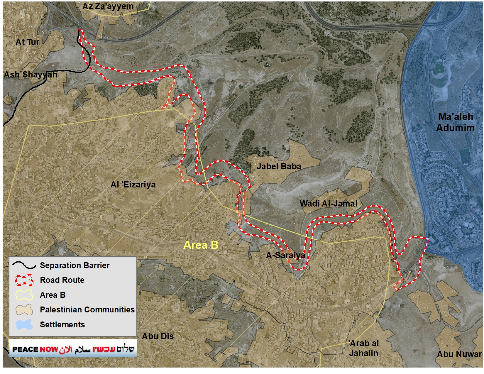
In terms of changes in the area, the announcement reads that the road “will close the entrance to el-Azariya from the direction of the city [Ma’ale Adumim], promote the movement of the security barrier between us and el-Azariya and allow the a-Za’im checkpoint to be moved in the direction of Mishor Adumim.” – That is, Ma’ale Adumim will be physically separated from the Palestinian space by a barrier, and thus there will no longer be a need for the checkpoint that is currently between Ma’ale Adumim and Jerusalem to prevent Palestinians from entering Israel.
The checkpoint will pass east so that the Israeli residents of Ma’ale Adumim will not have to pass through the checkpoint every day on their way to Jerusalem, and that the Palestinians will not have access to the area between Jerusalem and Ma’ale Adumim, and even east of it.
“This will be a separate road for Palestinians in the E1 area, the purpose of which is to separate the transportation connection between the Palestinian and Israeli populations in the area so that Palestinian vehicles will be allowed to pass without entering the Ma’ale Adumim bloc, near Jewish communities.” – That is, the purpose of the road is to separate the Palestinian traffic that will travel on one road, and the Israelis and the “Jewish communities” that will travel on other roads in a separate area. The Palestinians will not even be able to pass within the so-called Adumim bloc.
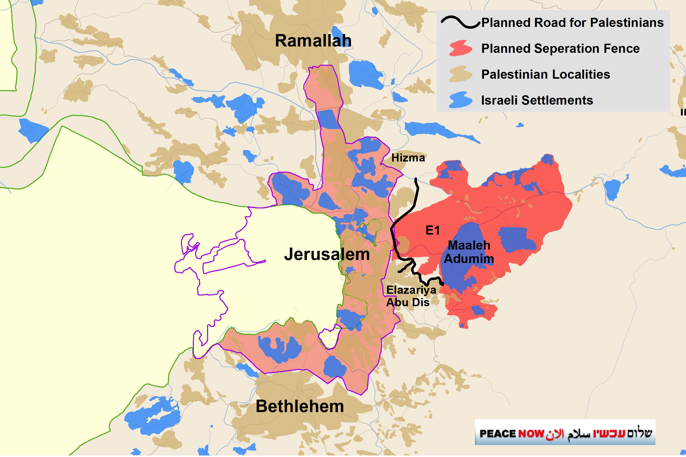
The announcement goes on to explain the political implications of the road: “At the political level, the road will connect Jerusalem and Ma’ale Adumim and enable construction in the Jewish settlements in the E1 area.”
Peace Now: “Netanyahu’s election campaign is costing Israel a very heavy price. Once again, he is using the election period to try to impress key Likud supporters by promoting a plan that could eliminate the possibility of a two-state solution. The planned road will allow Israel to cut the West Bank in two, build E1 and the separation barrier, and close the door on the possibility of developing a sustainable Palestinian state.”
Israel’s Plan: Transportational Contiguity in Place of Territorial Contiguity
The new road is intended to allow Palestinians to pass under the route of the separation barrier, and to travel “inside” the Adumim Bloc along a wall without entering the “Israeli” side, as in a kind of tunnel. Once the road is paved, Israel can then claim that construction in E1, and the construction of the barrier around the Adumim bloc does not sever the West Bank because the Palestinians have an alternative transport route. This argument is preposterous. A thin line of road connecting separate territorial sections–transportational contiguity–does not meet the needs for territorial viability for the development and livelihoods of Palestinians in the critical Ramallah-Jerusalem-Bethlehem metropolitan area. Without actual territorial contiguity, an independent Palestinian state cannot be established and prosper, and therefore a two-state solution cannot be reached.
The two-state solution depends on the possibility of establishing a viable Palestinian state alongside Israel. The heart of the future Palestinian state geographically, economically, and culturally is in the metropolis between Ramallah, East Jerusalem and Bethlehem. One of the only potential development areas left for this metropolis are the areas east of Jerusalem, in the same area where Israel seeks to build the E1 settlement and create an Israeli territorial continuum from Jerusalem eastward that would effectively cut the West Bank in half.
Recall that about two years ago, the northern part of this fabric of life road (also known as “apartheid road”) was opened, and drew severe international criticism.
For more information about the roads and infrastructure plans, see here.