
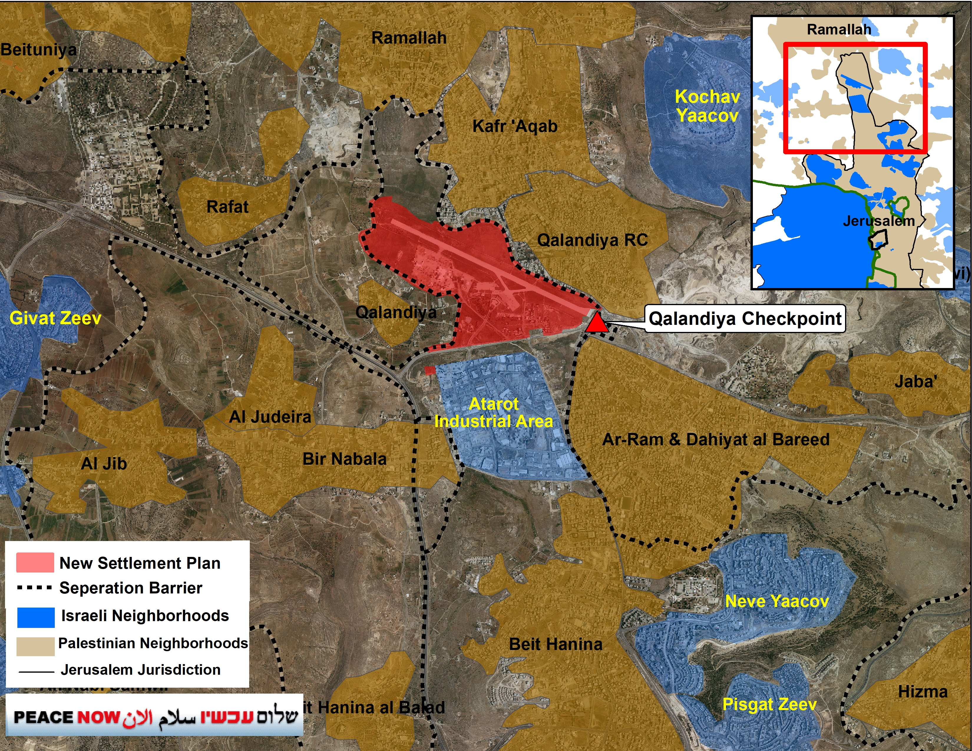
On Wednesday, December 17, 2025, the District Planning and Building Committee will discuss moving forward with a new neighborhood in northern Jerusalem. The Atarot neighborhood is planned to include 9,000 housing units on the site of the abandoned Atarot airport (Plan 101-0764936). The plan has features reminiscent of E1 in its implications for the region’s future and the building of a Palestinian state.
The new settlement – neighborhood would be built within a densely populated Palestinian urban area. It would stretch from Ramallah and Kufr Aqab in the north through the Qalandiya refugee camp, Al-Ram, Beit Hanina, and Bir Nabala. At the upcoming meeting, the planning committee is expected to approve the plan’s main outlines, including commercial areas and public space. A previous attempt to move the plan forward in late 2021 faced objections from the Environmental Protection and Health Ministries, so it did not go beyond the deposit stage.
During the Obama administration, the plan was stopped due to opposition from the U.S. government.
In December 2025, the Finance Ministry asked the Knesset Finance Committee to approve an additional 16 million shekels for the Environmental Protection Ministry for “land rehabilitation projects”, including funding to rehabilitate the Atarot airport site in order to “rehabilitate contaminated land that constitutes a barrier to development plans that the state has an interest in advancing for housing.
Peace Now: “This is a destructive plan that, if implemented, would prevent any possibility of connecting East Jerusalem with the surrounding Palestinian area and would, in practice, prevent the establishment of a Palestinian state alongside Israel. The Netanyahu government is seizing every moment to bury our chances for a future of peace and compromise. Especially now, when it is clear to everyone that the ideas of ‘managing the conflict’ and ‘decisive victory’ have led to a security disaster for Israel, we must act to resolve the conflict.”
Location and Political Significance
The plan lies at the center of a built-up Palestinian urban continuum stretching from Ramallah, through Kufr Aqab and Qalandiya, to Beit Hanina and Shuafat, an area where hundreds of thousands of Palestinians live in close proximity. The settlement is meant to break up Palestinian continuity and act as an Israeli enclave. This would block Palestinian development in the central and most important city area of a future Palestinian state, the Jerusalem–Ramallah–Bethlehem metropolitan area.
The establishment of an Israeli neighborhood on the scale of tens of thousands of housing units, meaning bringing in tens of thousands of Israeli residents, would greatly complicate any future two-state agreement, because it would break up the territorial continuity of Palestinian areas and damage the potential for establishing a Palestinian capital in East Jerusalem.
The Planning Stage
In February 2020, the Housing Ministry sent the plan to the Jerusalem municipality to prepare it for approval. The plan completed the bureaucratic preparation process in the municipality’s planning departments and in the Planning Administration apparently within a few months, but it has not yet been brought forward for approval. The district committee’s professional staff usually sets the date to discuss depositing a plan. However, if a plan has far-reaching political implications, especially if started by a government ministry, it needs approval from political leaders.
If the plan is approved for deposit and the process proceeds without political or legal delays, it may be possible to grant final approval within roughly 6 months to 1 year. That would come after objections are filed and heard, and after the plan is approved and given legal effect. Because this is a government-initiated plan on “state land,” once it takes effect, it would also require a round of tender processes to select construction contractors. That process generally takes about six months to a year. After the winners are selected, contractors could apply to the municipality for building permits, a process expected to take 1 to 2 years, and construction could begin only then.
Land Ownership
Most of the plan area is designated as “state land,” apparently dating back to the British Mandate era, when the airport was built on the site. That designation allows Israel to advance the settlement without needing to expropriate land from private Palestinian owners. Still, significant parts of the area are designated as privately owned land. The plan calls for a land readjustment process without the owners’ consent, under which landowners would receive rights within the plan area in accordance with the value of the land they own.