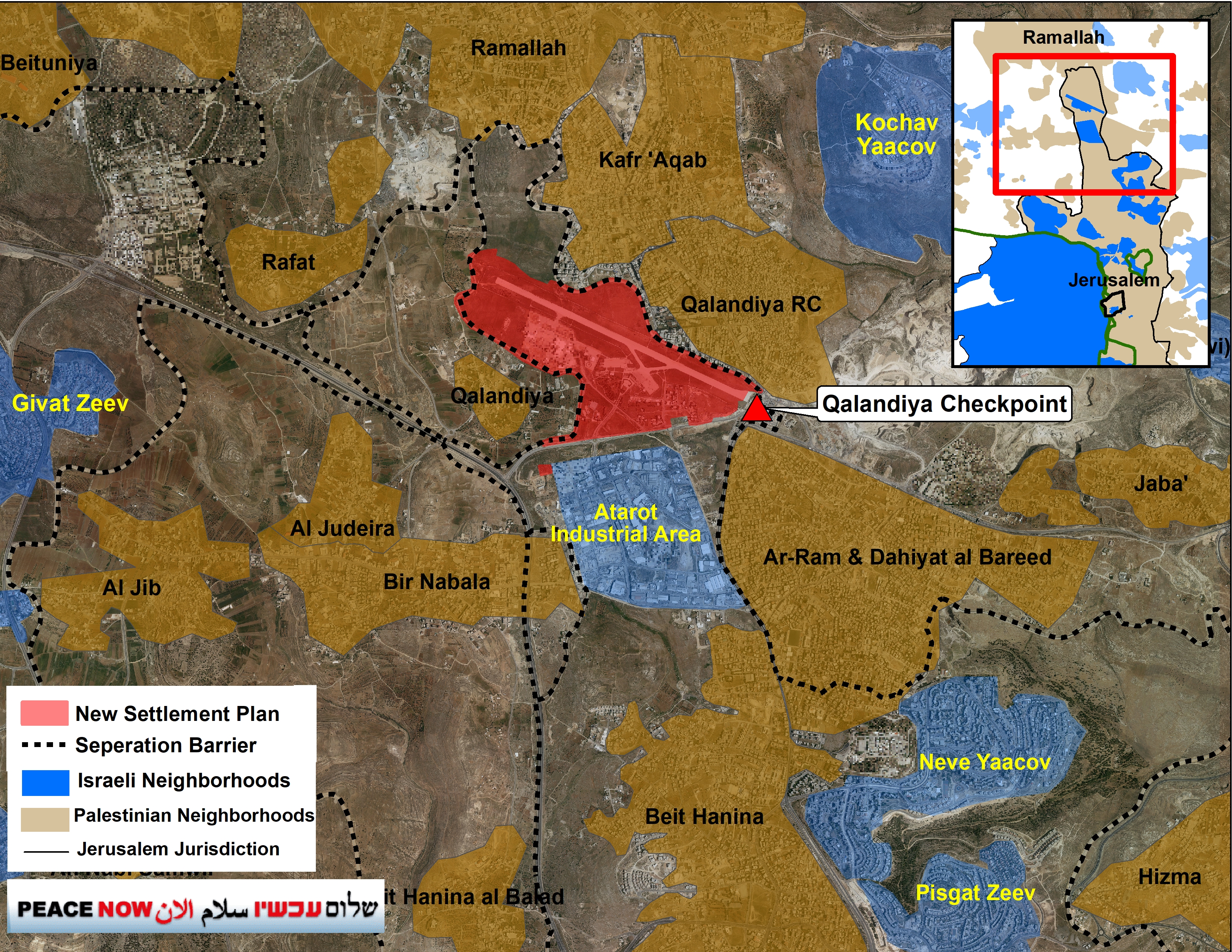
Reports from the media suggest that Netanyahu´s government will advance the construction plan in Atarot after a previous attempt to push forward the plan was met with opposition from the Ministry of Environmental Protection and the Ministry of Health in late 2021. The plan includes approximately 9,000 new housing units and a large commercial and industrial area.
Peace Now: “This is a highly dangerous plan that could land a fatal blow to the prospect of peace and two states. The Atarot plan puts a wedge in the heart of the existing Palestinian urban continuum between Ramallah and East Jerusalem, thus preventing the possibility of establishing a Palestinian state with its capital in East Jerusalem. If the plan is not removed from the agenda of Israel´s far-right and pro-settler government, an eventual political resolution will become even harder to reach.”

It is essential to mention that this plan was halted due to opposition from Obama´s administration throughout his tenure, along with other potentially destructive plans like the Givat HaMatos and Har Homa.
In the following week, Prime Minister Netanyahu will hold a discussion regarding the advancement of the plan in response to the recent terror attack in the neighborhood of Neve Yaakov.
This is a massive plan of 9,000 housing units (for comparison, Har Homa has about 6,000 housing units built according to three main plans), intended for the ultra-Orthodox population with an expected 50,000 residents, in the size of a small city in Israel. The plan is at the heart of the urban territorial Palestinian continuity starting in Ramallah, through Kfar Aqeb and Qalanadiya, to Beit Hanina and Shuafat, where hundreds of thousands of Palestinians live. The plan was meant to sever the Palestinian continuity and become an Israeli enclave which would prevent Palestinian development of the most central and important metropolitan area in the future Palestinian state, the Jerusalem-Ramallah-Bethlehem metropolitan area. Founding an Israeli neighborhood ranging thousands of housing units, would make any future two-state-based agreement difficult due to the lack of Palestinian continuity and harming the possibility of establishing a Palestinian capital in East Jerusalem.
Land ownership
Most of the plan counts as “state lands,” probably since the days of the British Mandate when the airport was built. This enables Israel to build the settlement without needing to confiscate lands from their Palestinian owners. At the same time, for the parts that are owned by private owners, the plan is aimed to create a procedure of “unification and division” (without agreement), according to which all land owners get a specific part according to the value of the land they own. It should be noted that the plan aims to demolish several buildings and Palestinian housing units that have been built in the area over the years.

Works in the Atarot/Qalandiya airport for parking for busses, July 2021

