
A few weeks ago two caravans were placed in the Tel Rumeida neighborhood, west of the Jewish cemetery, between a mosque and a Palestinian girls’ high school, on land that had, until now, seen no Israeli presence. According to the map of the Hebron Agreement, signed by Israel and the Palestinians in January 1997, this area falls under H1 – a zone under full Palestinian control (similar to Area A) – where, under an IDF military order, the entry of Israelis is prohibited.
Over recent months, dramatic developments have unfolded in the Tel Rumeida area of Hebron. At the end of March 2025, settlers entered the home of the Palestinian Tamimi family and established a settlement there, claiming to have purchased parts of the house. This new settlement, which settlers refer to as the “Gaon Yehuda neighborhood”, is surrounded by Palestinian homes and is disconnected from other settler enclaves in the city.
Around two months ago, the Civil Administration’s Staff Officer for Archaeology – the official body overseeing archaeological activity in the occupied territories – began a new excavation in Tel Rumeida. This dig is intended to expand the touristic settlement that has been operating in the area in recent years. The excavation is being carried out on land that is apparently privately owned by Palestinians.
The Palestinian residents of Tel Rumeida live under a regime of severe restrictions. For more than 20 years, the Israeli military has prohibited Palestinian vehicles from driving on the neighborhood’s roads. Residents must walk home on foot and carry all goods themselves. Over the past two years, the army has closed off all pedestrian access points into the neighborhood with checkpoints. Only residents registered as living in Tel Rumeida are allowed to enter – and only after inspection. The checkpoints remain open until 9:00 p.m. with one checkpoint supposedly open also after 9:00pm, however residents report that it is not consistently accessible.
Peace Now: The settlement in Hebron represents the ugliest face of Israel’s control over the occupied territories. Nowhere in the West Bank is apartheid more apparent. The Netanyahu-Smotrich government has no restraints. The establishment of a new settlement within a dense Palestinian area in Hebron, particularly in an area under Palestinian control, is a provocation that undermines Israeli political and security interests. Its establishment constitutes a violation of both a signed international agreement and Israeli military law.
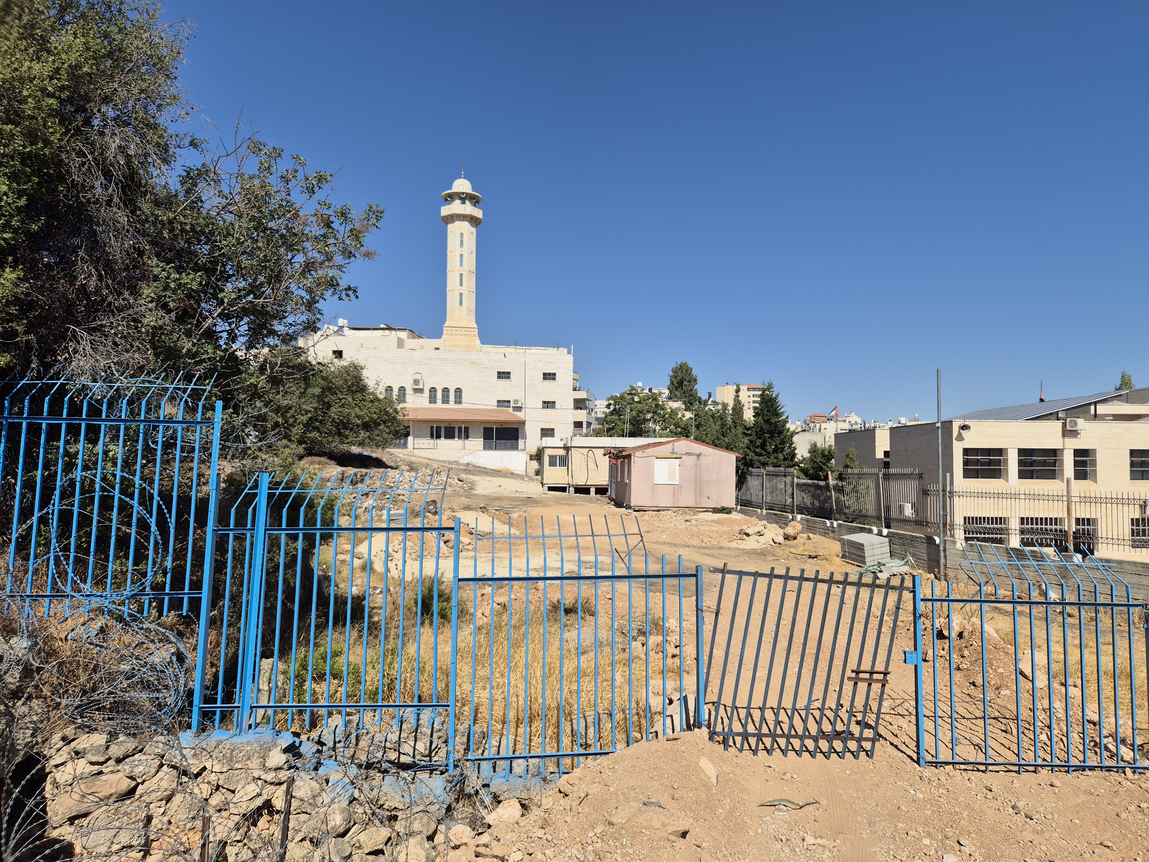
The caravans posted in H1 between a mosque and a Palestinian school
The New Settlement
The new settlement is situated on a plot of land west of the Jewish cemetery, adjacent to a mosque on one side and a Palestinian girls’ high school on the other. In order to establish the settlement, a fence was breached and the area was prepared for the caravans to be delivered. According to local Palestinian reports, immediately following the arrival of the caravans, access to the nearby school was blocked, as was one of the mosque’s entrances.
The new settlement is isolated and distant from the existing settler homes in Tel Rumeida and has far-reaching implications for the security deployment required to protect it. This impacts not only settlers but also the daily lives of Palestinian residents, worshippers at the mosque, and students attending the nearby school.
The caravans were placed on Plot 37, which was owned by Jews before 1948 and likely served as part of the Ashkenazi section of the Jewish cemetery. However, according to the map of the 1997 Hebron Agreement, which was signed by then-Prime Minister Netanyahu, the plot is located in H1 and is under full Palestinian Authority control. Furthermore, an IDF military order issued more than two decades ago prohibits Israeli entry into H1 areas.
Thus, beyond the significant security challenge posed by the new settlement, its establishment constitutes a violation of both a signed international agreement and Israeli military law.
It is worth noting that according to the map on the Civil Administration’s website, this plot is marked as part of H2. However, a review by Peace Now of the original map attached to the 1997 Hebron Agreement confirms that the land is in H1. It remains unclear why the Civil Administration altered the H2 map boundaries to include this area.
The fact that the area is in H1 is known even among settlers themselves. Around 20 years ago, when the girls’ high school was being built, Palestinians placed a caravan on the same Plot 37. At the time, settlers strongly objected, claiming the PA was desecrating the Jewish cemetery. Noam Arnon, then-spokesperson for the Jewish community in Hebron, was quoted as saying the land had been handed over to the Palestinians under the Hebron Agreement. Back then, settlers were outraged by the placement of a Palestinian caravan in the land of a cemetery. Today, however, when settlers place caravans on the same land, those same voices are silent.
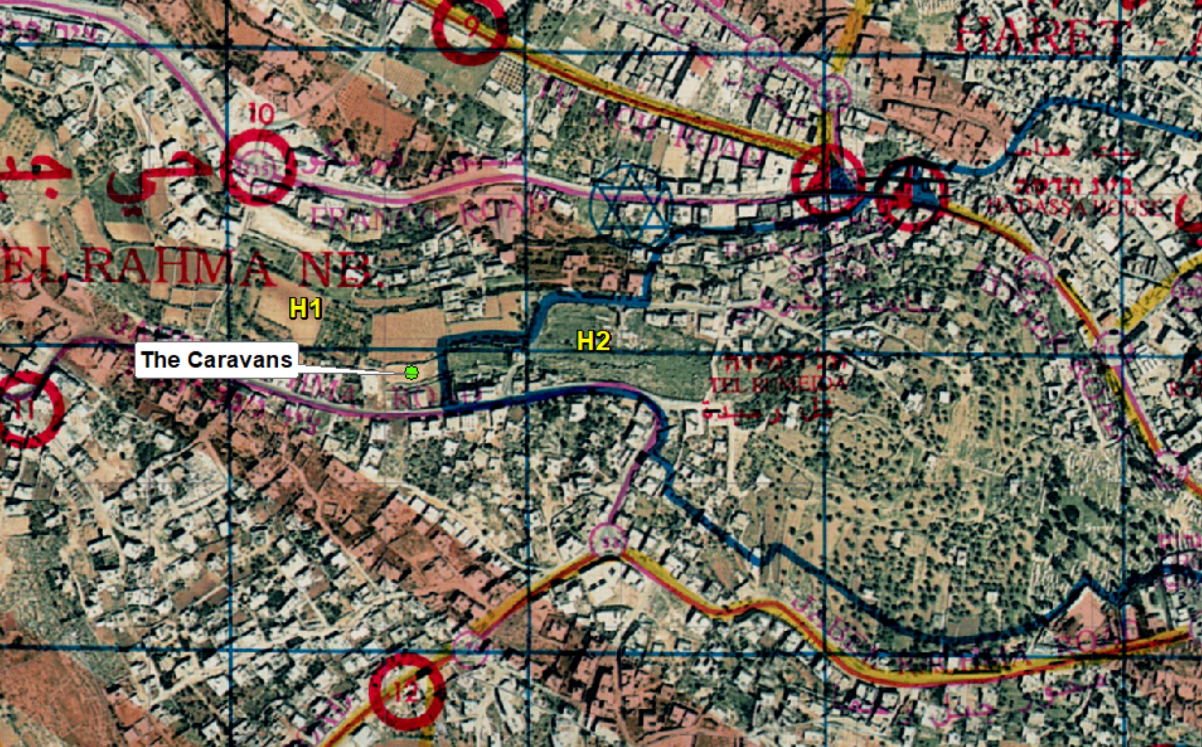
The location of the new caravans on the original map of the Hebron Agreement from January 1997
The Archaeological Excavation
The excavation is being conducted on land that had never previously been excavated, likely because it is privately owned Palestinian land used for agriculture. The dig is being carried out by the Civil Administration’s Archaeology Unit, with young settlers from the area taking part.
According to information available to Peace Now, the excavation is expected to conclude soon. The site will likely serve to expand the touristic compound, creating a contiguous line of settler presence from the homes in Tel Rumeida, through the archaeological site, and on to the “Gaon Yehuda” settlement established earlier this year in the Tamimi family home.